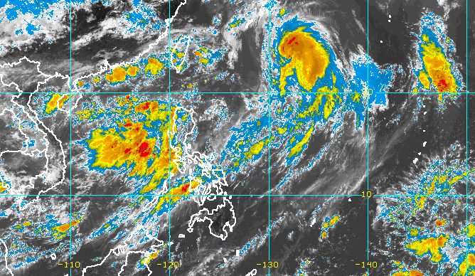
MANILA, Philippines – Typhoon Chedeng (Guchol) further weakened and accelerated while making its way out of the Philippine Area of Responsibility (PAR) on Sunday morning, June 11, but it was still enhancing the southwest monsoon or habagat.
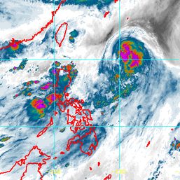
As of 10 am on Sunday, Chedeng was already 1,100 kilometers east northeast of extreme Northern Luzon, moving north northeast at 25 kilometers per hour from the previous 20 km/h.
The typhoon is expected to leave PAR on Sunday night.
Its maximum sustained winds decreased further to 120 km/h from the previous 130 km/h, while its gustiness went down to 150 km/h from 160 km/h.
Chedeng earlier reached a peak intensity of 150 km/h – referring to maximum sustained winds – on Saturday, June 10.
The Philippine Atmospheric, Geophysical, and Astronomical Services Administration (PAGASA) expects the typhoon to be downgraded to a severe tropical storm on Sunday.
Since Chedeng is staying far from the country’s landmass, it is not causing rain and tropical cyclone wind signals have not been raised.
But waters remain moderate to rough in the seaboards of extreme Northern Luzon due to the typhoon.
PAGASA advised small vessels to take precautionary measures as waves could be 2 to 3 meters high.

The moderate to heavy rain being experienced on Sunday is from the enhanced southwest monsoon.
In a separate advisory at 11 am, the weather bureau said the following areas will be affected by the southwest monsoon over the next three days:
Sunday, June 11
- 100-200 millimeters (mm): Ilocos Region, Zambales, Bataan, Occidental Mindoro
- 50-100 mm: Metro Manila, Bulacan, Abra, Benguet, northern part of Palawan including Calamian and Cuyo Islands, Antique
Monday, June 12
- 100-200 mm: Ilocos Region, Zambales, Bataan
- 50-100 mm: Abra, Benguet, Occidental Mindoro, northern part of Palawan including Calamian and Cuyo Islands
Tuesday, June 13
- 50-100 mm: Ilocos Region, Apayao, Abra, Zambales, Bataan
Floods and landslides are possible.
The southwest monsoon may also bring gusts, or sudden and strong winds, to these areas:
Sunday, June 11
- Batanes, Babuyan Islands, Ilocos Region, Cordillera Administrative Region, Nueva Vizcaya, Central Luzon, Metro Manila, Calabarzon, Mimaropa, Bicol, Western Visayas
Monday, June 12
- Batanes, Babuyan Islands, Ilocos Region, Cordillera Administrative Region, Nueva Vizcaya, Central Luzon, Metro Manila, Calabarzon, Occidental Mindoro, Oriental Mindoro, Romblon, Marinduque, northern mainland Palawan, Calamian Islands, Cuyo Islands, Kalayaan Islands, Bicol, Western Visayas
PAGASA said Chedeng’s effect on the southwest monsoon will lessen as it moves further away from PAR, but a frontal system north of extreme Northern Luzon “will continue to mainly enhance the southwest monsoon from Tuesday (June 13) onwards and affect most of Luzon, especially the western and extreme northern portions.”
That means rain and gusty conditions due to the enhanced southwest monsoon may persist Tuesday onwards, even after Chedeng’s exit.
Chedeng is the Philippines’ third tropical cyclone for 2023 and the first for June. PAGASA earlier estimated there would be one or two tropical cyclones during the month.
The weather bureau announced the start of the rainy season on June 2. – Rappler.com


There are no comments yet. Add your comment to start the conversation.