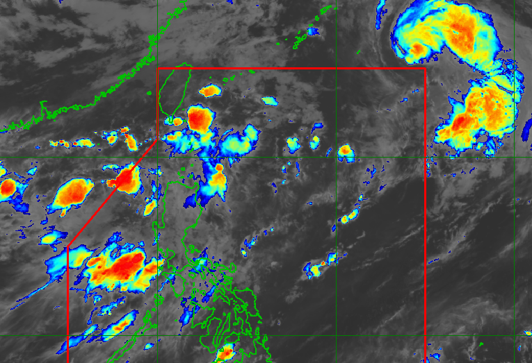
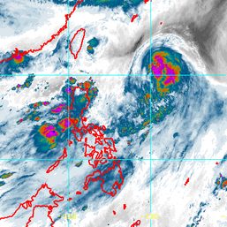
MANILA, Philippines – Severe Tropical Storm Chedeng (Guchol) left the Philippine Area of Responsibility (PAR) on Sunday evening, June 11, but it will continue to enhance the southwest monsoon or habagat.
As of 10 pm on Sunday, Chedeng was already 1,375 kilometers east northeast of extreme Northern Luzon, moving northeast at a faster 35 kilometers per hour from the previous 25 km/h.
The severe tropical storm is heading for the sea south and southeast of Japan, the Philippine Atmospheric, Geophysical, and Astronomical Services Administration (PAGASA) said in its 11 pm bulletin on Sunday.
Chedeng continues to have maximum sustained winds of 110 km/h and gustiness of up to 135 km/h.
It was a typhoon before it weakened into a severe tropical storm on Sunday afternoon. It had reached a peak intensity of 150 km/h on Saturday, June 10.
After Chedeng developed inside PAR last Tuesday, June 6, it stayed far from Philippine landmass.
It did not trigger rain and tropical cyclone wind signals were not raised, though it did cause moderate to rough waters in some seaboards.

Chedeng has also been enhancing the southwest monsoon. And, aside from the tropical cyclone, a possible frontal system north of extreme Northern Luzon on Tuesday, June 13, could cause enhancement of the southwest monsoon as well.
Floods and landslides remain possible in the next few days as the southwest monsoon is seen to bring more rain.
Sunday night, June 11, to Monday night, June 12
- 100-200 millimeters (mm): Ilocos Region, Zambales, Bataan
- 50-100 mm: Metro Manila, Bulacan, Benguet, Occidental Mindoro, northern part of Palawan including Calamian and Cuyo Islands, Antique
Monday night, June 12, to Tuesday night, June 13
- 50-100 mm: Ilocos Region, Zambales, Bataan
Tuesday night, June 13, to Wednesday night, June 14
- 50-100 mm: Ilocos Region
The southwest monsoon enhanced by Chedeng may also bring gusts, or sudden and strong winds, to Batanes, Babuyan Islands, Ilocos Region, Cordillera Administrative Region, Nueva Vizcaya, Central Luzon, Metro Manila, Calabarzon, Mimaropa, Bicol, and Antique on Monday, June 12.
PAGASA added that most of Luzon might still see gusty conditions Tuesday onwards if the frontal system forms and also enhances the southwest monsoon.
As for coastal waters, the southwest monsoon may trigger moderate to rough seas in the northern and western seaboards of Northern Luzon, with waves 2 to 4 meters high, and the western seaboard of Central Luzon, with waves 2 to 3.5 meters high.
PAGASA advised small vessels not to sail in those seaboards on Monday.
Chedeng was the Philippines’ third tropical cyclone for 2023 and the first for June. PAGASA earlier estimated there would be one or two tropical cyclones during the month.
The weather bureau announced the start of the rainy season on June 2. – Rappler.com


There are no comments yet. Add your comment to start the conversation.